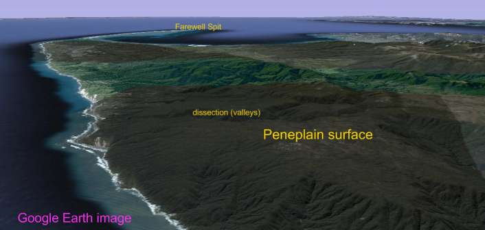
What is Peneplain?
The peneplain (from the latin parene = almost, and plain) designates a wide almost uniform plain, with slight unevenness a prolonged erosion and the coalescence of watersheds, originated in a horizontal modeling product. It is a set of watercourses and watersheds of low altitude with regard to the valleys, with some residual reliefs along the basin of the rivers. The peneplain would therefore be the result of the last stage of the geographical cycle produced by the river waters.This concept was developed by early geomorphologists, William Morris Davis and Walther Penck, at the beginning of the 20th century. Serious objections, an orogeny that has happened a prolonged phase of tectonic stability without the rejuvenation of the relief that would have allowed the normal development of the geographical cycle.After millions of years, the valley bottom plane are expanding more and more, joining with each other and finally forming a huge surface almost flat, that receives the name of peneplainsPeneplain is a concept that is frequently used in the field of geography. The term is used to name a surface similar to the plain, although with small elevations that interrupt the plain. The physiognomy of the peneplain depends on the consequences of erosion.Arguably, therefore, that a peneplain is a plain which lacks uniformity due to the action of erosion and hydrography, resulting in the formation of certain reliefs. The peneplain can be formed from the union of valleys, with over millions of years, giving place to a large quasi-flat terrain.The peneplain development involves the completion of a cycle of erosion, in which the reliefs are destroyed and remains almost flat with little elevation with respect to its base level.Elements that tend to form the peneplains are the remains of large rock formations which, due to the actions of the agents of erosion, lost lift. So that the process is carried out, needed an extended temporary period lacking interference; otherwise, the cycle is interrupted and the ground could achieve its rejuvenation.It is possible to find peneplains in various regions of the world. In Extremadura, an autonomous community of Spain, the peneplain dominates much of the territory. Castilla y León, another Spanish community, also has vast peneplains. In Latin America, Venezuela has peneplains in the region of Guayana,
Concept of Peneplain:
Landform that usually occupy large tracts and, due to erosion, presenting a surface gently undulating, without hardly a difference in height between the valleys and the watersheds. It consists of old and eroded materials.In temperate countries are recognized by the regularity of the surfaces, the watersheds have all the same altitude, the valleys have carved back these peneplains dating back to the tertiary. Training corresponds to the end of the cycle of erosion which is completed with the total destruction of the reliefs with the result of a monotonous relief and little raised above the base level.In Spain are located in the western part of the submeseta norte. The Extremadura peneplain is a great extension that has between 300 and 500 metres above sea level and consists of a Paleozoic base traversed by the Guadiana river.
Possible peneplain surface on granite, Heaphy Track area
Source: https://ncealevel2sci.wikispaces.com/